Decomposing Dead: 154 unclaimed body parts were recovered after a deadly late-night landslide — who’s to blame?
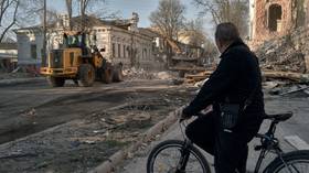
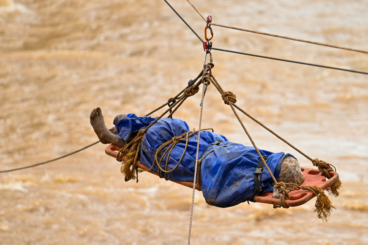
It wasn’t just 30 unidentified bodies but also 154 body parts that were laid to rest in south India’s Kerala on August 6 – the outcome of a disastrous landslide in the Wayanad district in the early hours of July 30.
Each whole body and each body part was wrapped in white cloth and buried in individual pits, in what was a mass burial at Puthumala in Wayanad, followed by an all-religious prayer. The burial lasted hours.
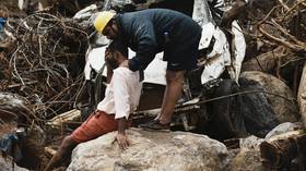
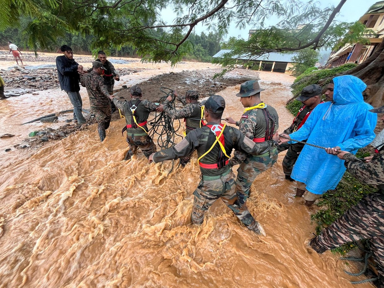
In total, 224 people died and 154 disappeared in the landslide, according to official data released by the state government. A total of 8,246 people were shifted to relief camps. Some bodies and body parts were flown to the Chaliyar River in Malappuram, a neighboring district.
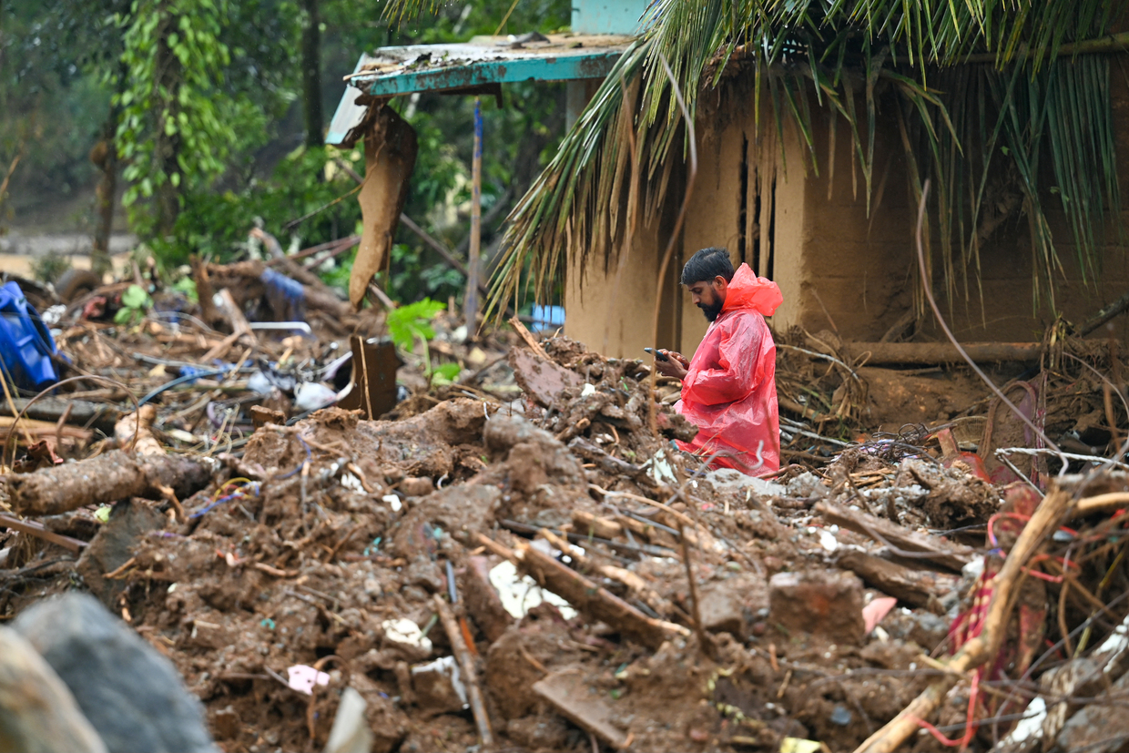
The landslide wiped out two villages, Mundakkai and Chooralmala, killing hundreds of people in no time. A government-run school vanished. Search operations continue from the landslide’s epicenter at Punchiri Mattam, with a focus on the areas along the path of the debris. Efforts have been expedited to identify unidentified bodies through DNA (genetic) testing.
The landslide is the worst since the 2018 floods that killed over 450 people. A landslide followed in 2019, killing 121 people. In Malappuram, 46 died in a landslide in 2019. The state saw landslides in Idukki district in 2020 with a death toll of 66. Other Indian states hit by landslides in recent years include Himachal Pradesh, Manipur, and Uttarakhand in 2018, and Manipur in 2017.
Wayanad, located in the north-east corner of Kerala, is part of the Western Ghats, north-south range along the west coast on the edge of India’s southern peninsula, known as the Deccan. It is a plateau that is parallel to the Malabar Coast of the Arabian Sea. The Western Ghats are a biodiversity hotspot, a biologically rich but threatened region and a UNESCO World Heritage site. They play a role in India’s monsoon weather pattern.
Relentless rain
Kerala receives India’s second-highest monsoon rainfall (after its seven northeastern states). It records an average annual rainfall of about 3,107 millimeters, of which 75% comes during the monsoon.
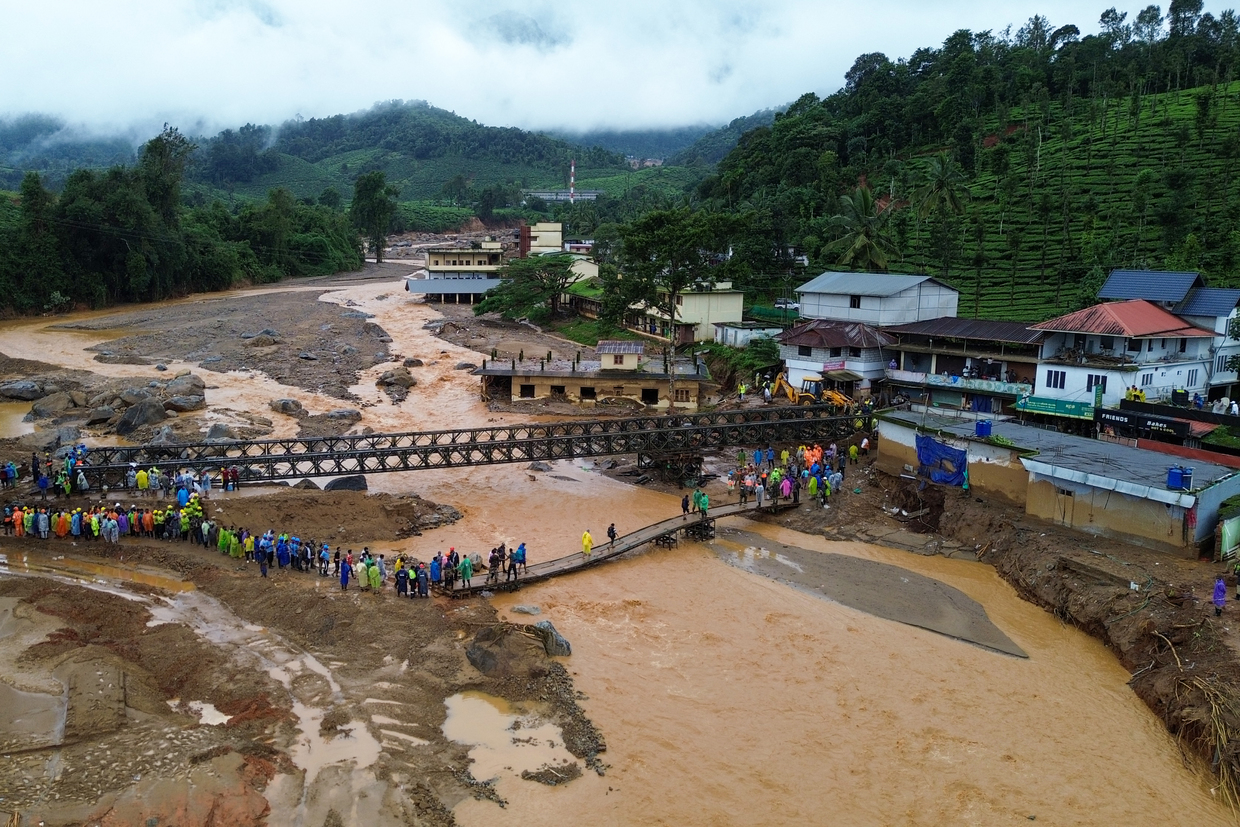
Torrential rains of 572 millimeters in just 48 hours preceded the landslide by a couple of days. It was significantly more than predicted by the India Meteorological Department (IMD).
While a classic morphological cause of landslides is erosion or weakening of the earth due to water, there are geological factors too.
“Factors that cause landslides include soil formation and rock types in a region,” Dr V Ambili of the Geological Survey of India (GSI) told RT. “In addition, the season also matters. Heavy rainfall in a short time-span makes a region saturated, and 99.9% of landslides in Kerala are accelerated by such intense rain.”
She added: “The high-slope regions of the Western Ghats are landslide-prone areas. The water level getting super-saturated was a triggering point this time. There is a limit to the volume of water soil can hold. The water can evaporate, flow as a stream, or be absorbed by plants if there is no intermittent rain. But beyond the threshold it will burst out like a landslide.”
Political row
The landslide has kicked off a political row. On August 5, Bhupender Yadav, the central minister for environment, forest and climate change, accused the Kerala government of allowing illegal habitation and mining in the affected area. Kerala’s chief minister, Pinarayi Vijayan, responded the next day.
“By making such false statements the minister is insulting the victims of the tragedy,” he said. “Who are the illegal inhabitants? The plantation workers who died in the disaster or the common people who lived there on tiny units of land? They can’t be branded as illegal inhabitants. The state is yet to get over the shock of the disaster.”
Before this, the central home minister, Amit Shah, said that his government had given an early warning about the landslide to the state government on July 23, seven days before the incident, and then again on July 24 and 25. Vijayan called this “inconsistent with facts.”
“In the area where the disaster hit, only an orange alert (means very heavy rains from 6 cm to 20 cm of rain) was in place, with the IMD warning of rainfall between 115mm and 204 mm,” he said.
The Opposition Congress party moved a privilege motion against the home minister, alleging that he misled the upper house of parliament. Privilege motions relate to matters of urgency or importance that are allowed to precede the consideration of other matters.
The Communist Party of India, Marxist (CPI-M), and the Communist Party of India (CPI), constituents of the ruling Left alliance in Kerala, also submitted a breach of privilege notice.
Rahul Gandhi, the opposition leader in the Lok Sabha (lower house) won from Wayanad during the summer election but vacated the seat to retain the Raebareli constituency in Uttar Pradesh. He visited the disaster site with his sister, Priyanka, who is expected to contest the Wayanad seat to replace him.
‘Landslides cannot be predicted’
“The warning system clearly says there is no system to predict a landslide, although there are means to find out landslide susceptibility or vulnerable areas,” Dr. KG Thara, former head of the State Institute for Land and Disaster Management Center, told RT, thereby rubbishing Amit Shah’s claim.
“As per the Disaster Management Act (2005), only the warning of central designated agencies can be taken into account, not those of private agencies unless approved,” she said. “The IMD gave an orange alert which meant be prepared. The day after the landslide the IMD scaled the alert up to red (which indicates heavy to extremely heavy rains of over 20 cm in 24 hours). The IMD relies on rainfall.”
According to the GSI, there are 14 parameters including rainfall for identifying a landslide-prone area. “Unless you have installed rain gauges widely, you can’t have location-specific data,” Dr Thara said. “In Mundakkai, there was no rain gauge and we couldn’t take data for predicting a landslide. From the boulders of rocks we can’t say that rainfall intensity was the only causative factor, there are other factors.”
GSI launched an app and a website for early warning of possible landslides and opened a National Landslide Forecasting Centre in Kolkata, in West Bengal, in July.
“In Kerala, a trial run has started for the warning system. We will develop a full-fledged warning system in a year,” Dr Ambili said.
“It is not about predicting that a landslide will happen at a particular location. We can warn about the possibility of a landslide as it depends on the intensity of the rainfall. A landslide may not happen in torrential rains if there is an hour gap in between, because water would flow out and prevent saturation. This is the same as predicting rain: we can’t predict but we warn that it may happen.”
Dr. Ambili pointed out that a landslide is a natural phenomenon and the triggering factor or root cause is not human intervention. “The magnitude depends on human intervention,” she said.
Need for advanced forecast models
Vijayan on August 3 stressed the need to make weather prediction models more modern, location-specific, and accurate so that disaster mitigation measures can start early.
Dr Thara asserted the need to undertake a location-specific detailed analysis of each area in the state. “We need to update the map after 2018,” she said. “Our hazard maps date back to 2002. Micro-scale mapping needs to be done and hazard zonation (systematic assessment and classification of areas based on their susceptibility to various hazards) needs to be done to identify where people can stay and people can’t stay. We don’t have a land use plan, on which land can be used for habitation and which can be left alone.”
Dr Ambili said there was a need to create awareness about living in such terrain and what to do in case of a calamity warning.
“The awareness should start from school,” she said. “We shouldn’t allow such regions to be overpopulated, and we should build eco-friendly structures. We need a well-planned system with people living in safer areas in such terrain while plantations can be developed in the less safe areas. A natural calamity can’t be stopped but casualties can be prevented.”