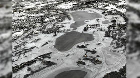
This ‘aerial’ photo of frozen lakes is not what it seems

It may look like a beautiful panoramic snap of frozen lakes in a desolate tundra landscape but this ‘aerial’ photograph is not what it seems to be.
Josh Newcomb from Post Falls, Idaho, was outside on Christmas day when he spotted that the lines that had formed in the ice had created a type of optical illusion.
“Went outside Christmas morning and noticed the interesting lines that had formed in the ice. Looked almost like a topographic map, so I just snapped a few pictures,” he explained to RT.com.
New Year’s Day I was going through my photos, and when I saw the thumbnail images I noticed that it looked like more like an aerial photo taken via drone or airplane.
The 26-year-old loves photography and the outdoors and is always snapping pictures of things that catch his eye. Without giving it much thought he uploaded the photo to Reddit and was taken aback when the post quickly went viral.
“I posted it to Reddit under r/mildlyinteresting without thinking too much of it. Checked my phone a few hours later to see that I wasn’t the only one to be fooled by the illusion,” he said “It blew up and I made the front page of Reddit. Definitely a great way to start the year!”
Also on rt.com 1st PHOTO of moon’s ‘mysterious’ far side taken by Chinese probeSeveral commenters noted that if Josh had posted the photo with a caption claiming that it is an aerial view of four lakes he would have fooled many people. So, naturally, that’s exactly what someone else went and did.
The photo was uploaded to Reddit Pics with the description “air view of four lakes, Canada”. The new post quickly racked up more than 1,400 ‘upvotes’ as well as dozens of entertaining comments from people who were in on the joke, as well some from others who seem to have been fooled.
This exchange is just a taste of the action:
Like this story? Share it with a friend!


