Quake enigma: The more it shakes, the less it shows
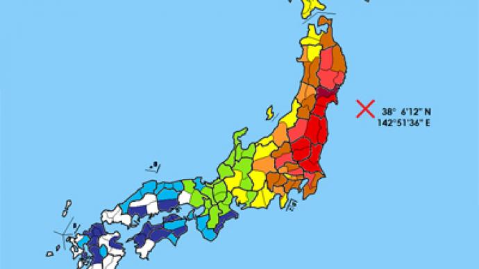
The 9.0 magnitude earthquake and the subsequent tsunami that devastated Japan’s east coast exactly one year ago were not supposed to happen. At least if seismic hazard maps are not cheating. But can modern science really predict such disasters?
As Joel Achenbach noted quite rightly in his Washington Post article, Earth paid no heed to scientific orthodoxy. And while geologists were theorizing, a massive slab of our planet’s crust moved 55 meters (180 feet) eastwards. It lifted the ocean bed almost 5 meters up (15 feet), and that brought all the might of the waters of the Pacific upon Japan’s eastern coast.The Tohoku area of Japan’s main island of Honshu suffered the most. The quake and the tsunami killed about 20,000 people and wiped out entire towns in several coastal prefectures. And yet no other consequence of this natural catastrophe inflicted so much horror around the world as the Fukushima nuclear crisis.When the tsunami hit the Tohoku area, the destruction it caused led to wide-scale power outages. The latter caused failure of cooling systems of the Fukushima nuclear power plant and, eventually, a meltdown of the radioactive fuel inside the plant’s nuclear reactors.
Science caught off guard
The 2011 disaster that hit Japan was not the only one to humble the international scientific community. The same applies to a series of devastating earthquakes that took place at different times since 2004 – in the Indian Ocean, Haiti, China, and New Zealand.In the aftermath of these disasters, and most of all the one that happened in Japan, geologists now feel the need to reexamine their basic knowledge pertaining to earthquakes.“This is a humbling field. If you want to be smug, don’t be an Earth scientist, and certainly don’t be an earthquake researcher,” the Washington Post cited Ross Stein of the US Geological Survey as saying.Seismic hazard maps usually show where quakes are most likely to strike over a certain period of time, as well as the expected intensity. However, some argue that these maps are nothing more than a description of past events and have limited value if we want to foresee disasters. The trouble is that some geological faults may endure thousands of years of strain before a catastrophic rupture.Supporters, on the other hand, argue that such maps are better than nothing. They may help policymakers decide, for instance, where to direct their efforts in the construction of wave fortifications and see which buildings may require some form of seismic retrofitting.
Anytime, anywhere
Japan’s 3/11 quake brought the realization of the fact that massive earthquakes can basically happen in any place where one tectonic plate is diving beneath another, no matter what seismic hazard maps tell. For decades, geologists believed that some of these areas were much more likely to generate a powerful earthquake.“[We] must allow for the possibility of larger earthquakes in regions where we thought that potential did not exist. That is one difficult lesson that we can consider learned,” a seismologist at the University of California at Santa Cruz, Thorne Lay, noted in his Nature commentary.This view is now shared by many other experts. Robert Geller, a geophysicist from the Tokyo University, is among them. He says that standard maps “are simply wrong” and based on the false assumption that earthquakes repeat themselves at more or less regular intervals.
Disturbing examples
Many recent earthquakes only confirm that this natural phenomenon is rather eccentric and virtually unpredictable. The location of the 9.1-magnitude quake that occurred in the Indian Ocean in December 2004 surprised many scientists. The zone near Sumatra which triggered the quake had been considered a relatively quiet area. The disaster took the lives of 230,000 people in Indonesia, Thailand and other countries, Most of whom fell victim to the tsunami that followed the shakes.Another such example is the 2008 earthquake in China’s Sichuan province, which killed 68,000 people. The fault which triggered the 2010 quake in Haiti used to be considered of less concern, unlike another fault to the north. Both of New Zealand’s recent significant earthquakes occurred on faults which were not even mapped.Recent examples show that similar events are also likely in places which would typically be considered unlikely for any seismic disaster to happen. As recently as in August, the Virginia earthquake in the United States damaged the Washington Monument and the National Cathedral.Given how densely-populated many coastal areas are, with most of them lacking even basic evacuation infrastructure, we are virtually left to guess where the next disaster is going to strike – because this time, it may well appear that science is not the answer to everything.


