Scientists solve mystery of millennia-old gravity-defying rocks in California

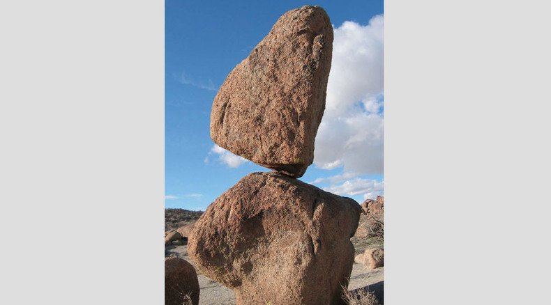
Giant rocks have been balancing precariously in California for thousands of years, puzzling geologists and seemingly defying gravity. However, the stones may provide clues to the inner workings of the famous San Andreas Fault, according to a new study.
Despite being near active faults, the granite stones – appropriately called Precariously Balanced Rocks (PBRs) – never topple. It's a mystery that has managed to continuously stump scientists.
While there are more than 1,200 PBRs in California and western Nevada, researchers decided to zero in on a group in the San Bernadino Mountains a few years ago – simply because they seemed to defy the odds even more than others in the region.
Explosive helium leaking from deep earthquake fault zone in S. California – new study http://t.co/5HMSYeibz0pic.twitter.com/zR6Mbohtue
— RT (@RT_com) July 1, 2015Those PBRs, ranging from 10,000-18,000 years old, are located extremely close to the large San Jacinto Fault, right where it edges near the notorious San Andreas Fault. It's a pretty dangerous location, considering California's close relationship with earthquakes.
“Based on what we know about the physics of earthquakes and fault ruptures, these shouldn't be here,” Lisa Grant Ludwig, lead author the study and professor of public health at the University of California, Irvine, said, as quoted by Discovery News. The study was published in the latest issue of the journal Seismological Research Letters.
But after over a decade of research, Grant Ludwig and her team determined that the rocks may actually be staying in place because of – not in spite of – the ways in which the San Andreas and San Jacinto faults work with each other. In other words, their interaction weakens ground-shaking during earthquakes, lessening the impact felt by the rocks.
California’s ‘Big One’ could trigger super cycle of destructive quakes – leading seismologist http://t.co/HS1zABiKuWpic.twitter.com/Hg4YHEko1N
— RT (@RT_com) April 23, 2015"These faults influence each other, and it looks like sometimes they have probably ruptured together in the past,” Grant Ludwig said. “We can't say so for sure, but that's what our data point toward, and it's an important possibility that we should think about in doing our earthquake planning.”
The data was derived using 3D computer modeling to study the rocks, determining how much force it would take to knock them over in three scenarios envisioned by the US Geological Survey (USGS): a magnitude 7.8 rupture of the southern San Andreas, a 7.4 earthquake near San Bernardino, and a replay of the 7.9 earthquake near Fort Tejon in 1857.
The computer models indicated that under these scenarios, the rocks should have toppled long ago – particularly during the great earthquakes of 1812 and 1857. The fact that they didn't likely means the rocks were located where the two faults interacted, benefiting from a softening of the ground shaking that would normally occur in a powerful quake.
4.1 magnitude earthquake recorded in Yountville, California http://t.co/b5gsrcyEwlpic.twitter.com/Fn5OJO3Xme
— RT (@RT_com) May 22, 2015But despite the two faults presumably working together to lessen damage, it seems they can equally go off together – which could mean a huge earthquake for inland Southern California, study co-author Julian Lozos, a postdoctoral researcher at Stanford University, told Live Science.
For this reason, identifying PBRs near active faults could help officials plan for future earthquakes, as local communities could use the data to prepare the local water supply, telecommunications and energy systems. The information could also be used to draw up hazard maps and implement building codes.
PBRs form when tectonic processes allow a large chunk of rock to ascend from beneath the surface of the Earth. As the rock rises, wind, water, and other natural processes erode pieces of it away, chiseling out the remaining delicately balancing rocks, according to Lozos.


