Mass evacuations, burned property as massive wildfires rage in California (PHOTOS, VIDEOS)

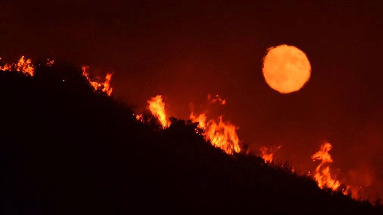
Wildfires caused by a record heatwave are raging through California, burning properties, injuring residents, and prompting massive evacuations. The flames even temporarily trapped children in a summer camp, officials said.
The blaze, which started earlier in July, initially affected Santa Barbara county. It then spread to California’s State Route, Highway 154, and got “completely out of control,” county fire Captain Dave Zaniboni said, as cited by AP.
A current view of the Alamo Fire from Tepesquete Road. pic.twitter.com/Sgoso72OhD
— Santa Barbara County (@countyofsb) July 8, 2017
The wildfires temporarily trapped at least 90 children and some 50 councilors at a local summer camp, Zaniboni said, adding that later the campers had been safely evacuated.
On Saturday, the blaze dubbed the Alamo Fire burned more than 23 square kilometers outside Santa Maria and remained 10 percent contained, Zaniboni added. The Santa Barbara blaze is one of three separate wildfires that have rocked California.
Some 300 residents were to evacuate Santa Barbara and neighboring San Luis Obispo County, AP reported.
#ParkfieldFire [update] off Vineyard Canyon Rd, 25 miles west of Parkfield (Monterey & San Luis Obispo Counties) is now 500 acres. pic.twitter.com/J5fe7EcdqQ
— CAL FIRE (@CAL_FIRE) July 9, 2017
“It’s a big fire and very unpredictable right now with the weather conditions, the heat, the wind, and we’ll keep our fingers crossed that the fire service will be able to contain this,” Santa Barbara County Sheriff Bill Brown said, as cited by NBC news.
This fire is spreading so fast! #AlamoFirepic.twitter.com/UVCxa5U8lb
— Elisa Borjas (@eborjas79) July 9, 2017
Columns of smoke and planes battling the blaze were seen in the area, according to photos and videos on social media.
In a separate wildfire near the town of Oroville in Butte County, five residents and one firefighter sustained minor injuries, the California Department of Forestry and Fire Protection said.
#ParkfieldFire [update] off Vineyard Canyon Rd, west of Parkfield (Monterey County) is now 75 acres. pic.twitter.com/aSnQCFc4BG
— CAL FIRE (@CAL_FIRE) July 9, 2017
That blaze destroyed 10 homes, the department added, releasing evacuation orders.
Another view of the backfire operation that Santa Barbara County Firefighters conducted along Tepusquet Canyon Rd. @KSBYpic.twitter.com/mn3wpeV0YZ
— Megan Abundis (@meganrabundis) July 9, 2017
“We’re doing our best to get our upper hand on it, but we have a lot to contend with, with the weather and the fuels that are out there – very dry,” Cal Fire Captain Amy Head told NBC affiliate KCRA.
“So, a long road ahead of us,” she added.
#AlamoFire [update] off Hwy 166, near Twitchell Reservoir (San Luis Obispo Co) is now 19,000 acres & 10% contained. https://t.co/3KR0HM0UMKpic.twitter.com/KfA7fP27BU
— CAL FIRE (@CAL_FIRE) July 8, 2017
The National Weather Service (NWS) has put a red flag warning on California due to “critical fire weather conditions.”
#WallFire [update] north of Bangor (Butte County) is now 2,700 acres & 20% contained. New evacs in effect: https://t.co/TEnJuhCJ0xpic.twitter.com/9crCBDk0W8
— CAL FIRE (@CAL_FIRE) July 9, 2017
Temperatures in downtown LA hit 98°F (36°C), which “exceeds a 131-year record set way back in 1886 when the high was 95 degrees,” the National Weather Service (NWS) reported.
The NWS also put a red flag warning on California due to “critical fire weather conditions.”
Vegetation Fire- #WhittierFire - A Santa Barbara City Fire vehicle drives on Highway 154 towards flames east of Cachuma Lake.*Call Newsline* pic.twitter.com/NwOp8lbQJd
— SBCFireInfo (@EliasonMike) July 8, 2017
“Low humidity, high heat and the winds are right – and there’s just a lot of stuff to burn,” said Santa Barbara County spokeswoman Gina DePinto.
#WintersFire [update] southwest of Winters (Yolo County) is now 2,269 acres and 75% contained. #WinterFirehttps://t.co/8lestFlc3xpic.twitter.com/3C2TsGvSUe
— CAL FIRE (@CAL_FIRE) July 9, 2017
She said the firefighters’ main focus on Saturday was to secure the south and east sides of the blaze. If the winds shift to the northwest, as expected, homes could burn, she said, as cited by LA Times.
Yesterday #alamofire@calfirepic.twitter.com/NHSAKe44Ab
— Monica G. (@13wrightmonica) July 8, 2017
On Thursday, the American Red Cross said it is providing shelter and meals for those affected by the blaze.
Whittier fire approximately 3300 aces, resources including aircraft from multiple jurisdictions on scene. pic.twitter.com/J5zlBNjskq
— Los Padres NF (@LosPadresNF) July 9, 2017
#AlamoFire [update] off Hwy 166, near Twitchell Reservoir (San Luis Obispo Co) is now 6,000 acres & 10% contained. https://t.co/3KR0HM0UMKpic.twitter.com/K128xjLHHY
— CAL FIRE (@CAL_FIRE) July 8, 2017
#WhittierFire view from Goleta. Burning in heavy chaparral and oak woodland. Additional resources on the way. pic.twitter.com/Zr2D3jf34p
— Los Padres NF (@LosPadresNF) July 9, 2017
#WhittierFire now approximately 5400 acres. Night flights occurring. pic.twitter.com/s4GcV1VnFZ
— Los Padres NF (@LosPadresNF) July 9, 2017


