Earth, fire & water: NASA maps atmospheric aerosols in psychedelic image

A new NASA image outlining the various types of aerosols in the air shows that we may be getting more than we bargained for with every intake of breath.
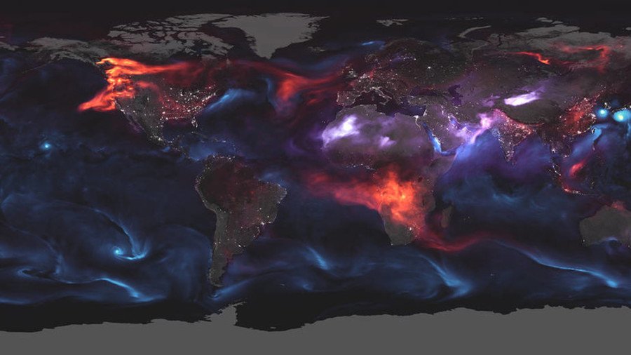
Aerosols – solid and liquid particles emitted from oceans, deserts, mountains and forests – are everywhere around us. But now NASA, using a model called the Goddard Earth Observing System Forward Processing, has developed a graphic that offers a sweeping view of where exactly on Earth these aerosols are being created and how.
Just another day on aerosol Earth: tropical cyclones, dust storms, and fires spread tiny particles throughout the atmosphere on August 23, 2018. https://t.co/wl9Py7DPFY#NASA#GEOS#HurricaneLane#CaliforniaWildfires#BCFires#Soulik#Cimaron#atmosphere#dust#blackcarbonpic.twitter.com/IOhAGFiAlt
— NASA Earth (@NASAEarth) August 23, 2018
The result is a swirling, psychedelic mish-mash of phosphorescent colors that represent each of the different types of aerosol in our atmosphere.
Blue marks the sea salt whipped up by ocean storms, while red represents black carbon emitted by vehicle and factory emissions, as well as various wildfires that continue to rage around the globe. Dust particles are highlighted in purple. The world’s major cities are marked using a day-night band from the space agency’s Joint Polar Satellite System.
The image was collated by the Earth-observing satellites Terra, Aqua, Aura and Suomi NPP. Each orbiter captures the tiny particles from a different perspective.
READ MORE: NASA astronaut asked ground control what the ‘alien-like’ object was that he saw in space
High aerosol amounts occur at various times around the world. According to NASA’s Earth Observatory, high levels occur over South America throughout the summer as forests are burnt in major land-clearing projects in the Amazon Basin. Similar incidents are seen in Central America and southern Africa.
Like this story? Share it with a friend!


