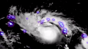
Stunning but deadly: Satellite imagery shows Hurricane Dorian sparkling as it approaches US (VIDEO)
Published 30 Aug, 2019 16:28 | Updated 2 Sep, 2019 10:38
As Hurricane Dorian makes its way to the US, a meteorologist has shared stunning satellite snaps of the “extremely dangerous” storm’s brightly colored lightning eruptions amid swirling clouds that look like a fireworks display.
Hurricane Dorian putting on a lightning show tonight. Spectacular imagery. pic.twitter.com/cdrs22PZqe
— Dakota Smith (@weatherdak) August 30, 2019
Meteorologist Dakota Smith shared the footage on Twitter and explained that the flashes seen in the storm’s inner core are “associated with deep convection that kicked off after sunset.”
Smith also shared footage of the hurricane taken at sunrise, after it had intensified, explaining it would “soon become a powerful major hurricane.” He then showed the eye of the storm as it formed. “A sure sign it’s getting stronger,” he said.
An eye emerges in Hurricane Dorian. A sure sign it's getting stronger.Marvelous hi-res imagery. pic.twitter.com/RpSrPksP1P
— Dakota Smith (@weatherdak) August 30, 2019
Hurricane Dorian is making its way towards Florida where the entire state is under a state of emergency in anticipation of the massive storm, which is expected to be a Category 4 by the time it makes landfall there on Monday.
The National Hurricane Center said Dorian poses a “significant threat” and people have been asked to stockpile a week’s worth of supplies to prepare for the “extremely dangerous” hurricane, which will have winds of 130 miles per hour.
Think your friends would be interested? Share this story!


