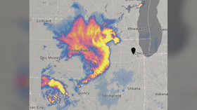
Massive 'dragon-shaped' windstorm headed for Chicago
Published 10 Aug, 2020 22:24 | Updated 10 Aug, 2020 22:24
An enormous “derecho” storm cluster with winds up to 100mph has taken shape in the midwestern US, leaving a trail of destruction in its wake and heading straight for Chicago - as if the Windy City doesn’t have enough problems.
The devastating storm - given the rare classification of “Particularly Dangerous Situation” by government meteorologists - is expected to pummel northern Illinois and southern Wisconsin with winds of up to 100mph (160kph) through 7pm local time, according to the US Storm Prediction Center.
The likelihood of a Derecho impacting IA, IL, IN, and WI this afternoon has prompted an upgrade to a Moderate Risk of severe weather and the issuance of a "Particularly Dangerous Situation" Severe Thunderstorm Watch. Widespread severe wind gusts of up to 80-100 mph are possible. pic.twitter.com/Bl5GP8fg0u
— National Weather Service (@NWS) August 10, 2020
Potentially causing more damage than a tornado, a derecho is defined as a “line” of thunderstorms stretching at least 250 miles (402km) with wind gusts above 58mph including multiple separated gusts of over 75mph. Damage caused by such formations is termed “straight-line wind damage” to differentiate it from that caused by tornadoes.
Anyone have dragon shaped derecho for their 2020 bingo? pic.twitter.com/BHPVL1XT8S
— BanhammersWrath (@BanhammersWrath) August 10, 2020
Monday’s derecho, which took the shape of a dragon in some ominous radar images, may also be accompanied by large hail and even a few tornadoes, according to the SPC.
NEW VIDEO: This power pole was no match for the strong winds in today's #derecho.With winds reaching over 100 mph in parts of #Iowa, we saw terrifying scenes such as this one. #IAwx#ILwx#WIwxpic.twitter.com/jArfNln1w3
— WeatherNation (@WeatherNation) August 10, 2020
Insane footage from the derecho moving through eastern Iowa this morning. This is from Belle Plaine, Iowa which is east of Des Moines but west of Cedar Rapids. #IAwxpic.twitter.com/nKdfonpveC
— Tyler Roney (@TylerJRoney) August 10, 2020
The storm system already tore through Iowa, leaving significant destruction in its wake. Wind gusts in Le Grand, Iowa measured 106mph.
Southwest Linn County hit incredibly hard as well. There's not a county road without damage. Power lines snapped, barns destroyed and corn flattened. #iawx#derecho@iowasnewsnowpic.twitter.com/AWI7Nlu6m2
— Nick Stewart (@NStewCBS2) August 10, 2020
2x4s punctured through a home in Perry 😳 #iawx📸: Jennifer Pickering pic.twitter.com/IgjgMcw99K
— Taylor Kanost (@WxKanost) August 10, 2020
The storm arrives as Chicago is still reeling from a night of protests sparked by a police shooting that quickly degenerated into massive looting. Chicago police have pledged to step up their presence in the downtown area, with Mayor Lori Lightfoot warning access to the business district will be restricted “until we know that our neighborhoods are safe.”
Also on rt.com Mayor of Chicago slammed for failed response to looting & police shooting after focusing on lakeside social distancingThink your friends would be interested? Share this story!


