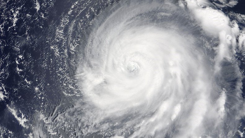
ISS astronauts snap spellbinding super Typhoon Noru from space (PHOTOS)
Published 1 Aug, 2017 20:31 | Updated 2 Mar, 2018 10:10
Astronauts aboard the International Space Station (ISS) have been sharing some awe-inspiring images of one of the strongest storms of the year so far – super Typhoon Noru.
Typhoon Noru is expected to make landfall around southern Japan this weekend, bringing an end to “a long and strange journey the tropical cyclone has already made through the western Pacific Ocean,” the Weather Channel reports.
When Mother Nature gets to spinning, it can be an awesome but scary sight. Looks like super Typhoon #Noru is gaining momentum. #EarthShapespic.twitter.com/hR8gyYlhEs
— Jack Fischer (@Astro2fish) August 1, 2017
Astronaut Jack Fischer and Cosmonaut Sergey Ryazansky posted eerie images of Noru from their vantage aboard the ISS as the typhoon gained momentum over the Pacific Ocean.
Прямо сейчас этот #супертайфун по имени #Нору «гуляет» над Тихим океаном. // Super #Typhoon#Noru swirling in the Pacific Ocean. pic.twitter.com/SUPOnXCM6h
— Сергей Рязанский (@SergeyISS) August 1, 2017
NASA’s Terra satellite captured a close look at the eye of the storm while passing over Noru in the Northwestern Pacific Ocean. On Tuesday, NASA measured Noru’s maximum sustained winds at 165kmph (103 miles).
NW PACIFIC OCEAN * Full Update* Typhoon Noru Gives NASA's Terra Satellite the Eye https://t.co/nWrEttmf6Xpic.twitter.com/Jsu3HUHJmg
— NASAHurricane (@NASAHurricane) August 1, 2017
READ MORE: Enormous sinkhole devours two homes, threatens Florida neighborhood
Noru grew from an ordinary tropical storm Saturday to a super typhoon, becoming Earth’s most intense storm of the year so far by Sunday.
Incredible loop of now Category 5, Super Typhoon #Noru in the Pacific Ocean. In just 24 hours, it exploded to a buzz saw. #Himawari. pic.twitter.com/WBCtO6Qk4J
— Nicholas Stewart (@NickStewartKHQA) July 30, 2017
In the Western Pacific, Typhoon #Noru has winds of 105mph, gusting to 125mph, with a pressure of 940mbars. Movement is Northwest at 8mph. pic.twitter.com/RzavaaiFX3
— Johnny Parker (@JohnnyParker012) August 1, 2017
On 7/30, Himawari-8 captured this imagery of Typhoon #Noru, w/ its 140 mph winds, spinning in the W. Pacific. https://t.co/NRUy68BLnYpic.twitter.com/eprRSOM7QY
— NOAA Satellites (@NOAASatellites) July 31, 2017
On Tuesday, Noru's strength was the equivalent to that of a category 2 hurricane. Japanese authorities are monitoring Noru’s progress closely and will prepare to dispatch emergency services as it ventures closer to the country’s coast.


