Storm Franklin builds in epic satellite footage (IMAGES)
Tropical storm Franklin looks set to become the first hurricane to hit the Atlantic basin this year as satellite images show the storm force intensifying.
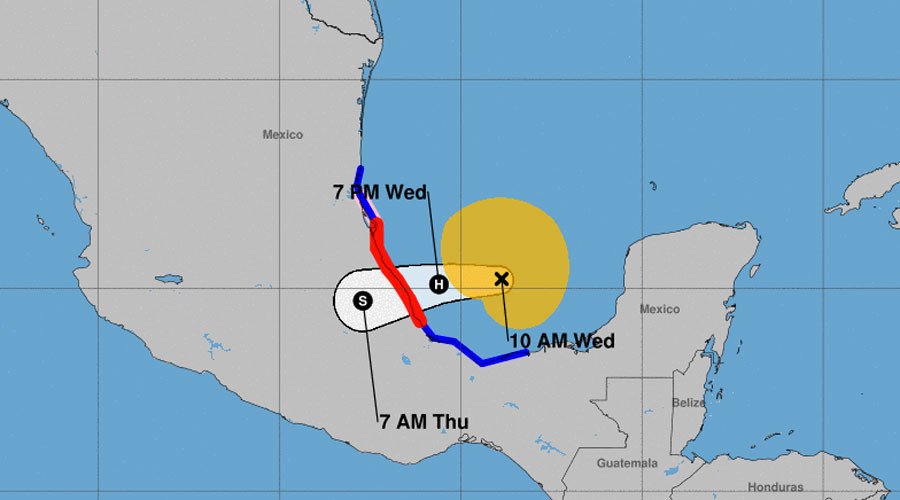
The storm formed over the western Caribbean Sunday and made landfall near Pulticub in southeast Mexico before battering the area with 60mph (95kmph) winds. The US National Hurricane Center forecasts that Franklin will make its second landfall in Mexico late Wednesday or early Thursday, as a hurricane.
#GOES16 captured this infrared imagery of the strengthening Tropical Storm #Franklin earlier today. More loops @ https://t.co/JtvCqQ1GU0. pic.twitter.com/ZVUibqcr5E
— NOAA Satellites (@NOAASatellites) August 9, 2017
TS #Franklin's central pressure has fallen to 985 mb - the lowest for a TC in the Bay of Campeche since Ingrid (2013). pic.twitter.com/5xq4lIxwrJ
— Philip Klotzbach (@philklotzbach) August 9, 2017
At 10am CDT Wednesday, Tropical Storm Franklin was found about 140 miles (225km) northeast of Coatzacoalcos, Mexico, and moving west. Satellite images show Franklin strengthening as its center moves towards Mexico’s east coast.
#Franklin continues with deep convection wrapping around center as it gets closer to being our 1st hurricane of 2017 in the Atlantic basin. pic.twitter.com/GHJtXcQtPx
— Jim Cantore (@JimCantore) August 9, 2017
Watch the swift intensification of Tropical Storm #Franklin as the storm pushed out over the Bay of Campeche via microwave imagery. pic.twitter.com/dHOjsfaEOY
— Michael Ventrice (@MJVentrice) August 9, 2017
Close up of Tropical Storm #Franklin; check out that tongue of low RH air wrapping into center of Franklin pic.twitter.com/UquTnkMzZj
— Michael Ventrice (@MJVentrice) August 9, 2017
#Franklin on the move this morning still trying to become Atlantic season's 1st hurricane of 2017. Its well on its way. FLASH FLOODING poss. pic.twitter.com/GEzCT0OSOV
— Jim Cantore (@JimCantore) August 9, 2017
Franklin is the sixth named storm of the season. Maximum sustained winds are currently recorded at near 70mph (110 km/h), with higher gusts. To be classified as a hurricane, a tropical cyclone must have maximum sustained winds of at least 74 mph.
A hurricane warning is in effect for the coast of Mexico from Puerto de Veracruz to Cabo Rojo, while a hurricane watch is in place for areas north of Cabo Rojo to Rio Panuco

#Franklin expected to become 1st Atlantic hurricane of 2017 later today right on schedule. Avg. date for first ATL hurricane is Aug 10th pic.twitter.com/p96mYamvDx
— Greg Diamond (@gdimeweather) August 9, 2017
Franklin is expected to cross the coast in the Mexican state of Veracruz tonight or early Thursday accompanied by heavy rainfall threatening flash floods and mudslides.
Up to three inches of rainfall are also forecast across parts of Belize and Mexico’s Yucatan Peninsula.


