7 of the finest images from Earth’s orbit

Luminous blue phytoplankton blooming in the Norwegian Sea, and textures of rich brown sediment flowing into the Arabian Ocean, are just some of the images captured by satellites orbiting the Earth in recent months.
Here are some of the best images taken from the Earth's orbit by NASA satellites and astronauts.
Blooms in the Caspian Sea https://t.co/8hw0VgAV9f#NASApic.twitter.com/GJW8Mp8qLw
— NASA Earth (@NASAEarth) August 9, 2017
This image of phytoplankton blooming in green swirls in the blue Caspian Sea was captured by NASA’s Moderate Resolution Imaging Spectroradiometer (MODIS) on the space agency’s Aqua satellite this month.
Lake Urmia to the west appears as a spot of rust as microorganisms react with the lake’s salt water to turn the surface a deep shade of orange.
Blooming Norwegian Sea https://t.co/XkjGP2hDjm#NASApic.twitter.com/DmTJHLw7dA
— NASA Earth (@NASAEarth) August 3, 2017
Another phytoplankton bloom – this time pictured off the northwest coast of Norway using the Operational Land Imager (OLI) on the Landsat 8 satellite.
The milky-blue color in the coastal waters suggests the bloom contains coccolithophores, a type of microscopic plankton are made up of white calcium carbonate.
Mackenzie Meets Beaufort https://t.co/DvhssDuWBR#NASApic.twitter.com/rsxossUcaL
— NASA Earth (@NASAEarth) August 6, 2017
The Mackenzie is the second largest river in North America after the Mississippi. Every year, a surge of fresh water comes down river after the ice and snow melts in the highlands, bringing with it huge amounts of sediment flowing in textured swathes into the Beaufort Sea, as seen above.
Pictured by the OLI in July, the Mackenzie River pushes this material out into the open ocean as the season progresses.
If you get the angle just right…it makes a river look like it’s on fire. Now that’s just cool. #EarthShapespic.twitter.com/Dbz1BfegL6
— Jack Fischer (@Astro2fish) August 6, 2017
Astronaut Jack Fisher published this photograph to his Twitter feed from aboard the International Space Station (ISS) Wednesday.
It shows the Zambesi and Cuando rivers meeting at night at a juncture of the borders between Zambia, Zimbabwe and Botswana.
Fisher captioned the picture: “If you get the angle just right… it makes a river look like it’s on fire. Now that’s just cool.”
They call it the Red Sea, but it sure has a lot of pretty blues – I’m amazed at how bright they are from space! #EarthShapespic.twitter.com/ZrwfZWhXiH
— Jack Fischer (@Astro2fish) August 3, 2017
Another from Fisher. The astronaut captures the tropical blue and green of the Red Sea near Egypt’s Elba National Park from the observation pod of the ISS.
Solar Evaporation Ponds near Moab, Utah https://t.co/nw50VomERW#NASApic.twitter.com/8wQcwkVKRz
— NASA Earth (@NASAEarth) August 7, 2017
This image, again captured aboard the ISS, shows the mosaic pattern of solar evaporation ponds outside the city of Moab in Utah. The surreal ponds are spread across 400 acres of arid, rocky landscape, and are used in an operation to mine muriate of potash (MOP), a type of fertilizer.
The colored ponds represent different stages of evaporation. The bluest waters are in the early stages, while the tan colored pools are almost dry and full of salt crystals which are ready for collection. The effect is that of a mosaic or stained glass.
When the Land Stains the Sea https://t.co/OnwfTODCxT#NASApic.twitter.com/u4aOL4lgwj
— NASA Earth (@NASAEarth) July 29, 2017
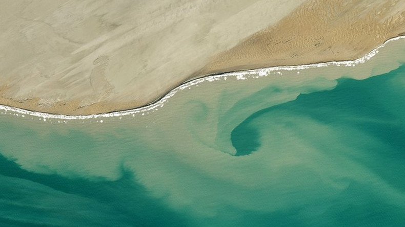
Pictured on Pakistan’s Makron Coast in May, a rush of sediment into the Arabian Sea is captured by the OLI.
After heavy rain, the nearby Hangol River carries sediment into the sea where the current sweeps it along the shore until it meets a dip in the underwater terrain, resulting in a swirl effect.


