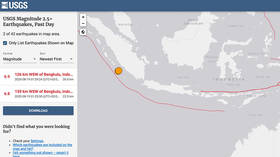
Twin 6.8 & 6.9 magnitude earthquakes strike Indonesia

A pair of powerful earthquakes has rocked the Indonesian coast, measured 6.8 and 6.9 magnitude, according to the US Geological Survey (USGS), shaking the island of Sumatra.
The two quakes struck off Sumatra’s western coast on Wednesday morning, with an estimated depth of 22km (13 miles) and 26km (16 miles) respectively. The first tremor impacted an area some 144km (89 miles) away from Bengkulu, while the second came closer to the city at 130km (80 miles).
There are no reports of injuries as of yet, however local media said the quakes shook the homes of island residents “as if a truck had passed” and did “minor damage,” particularly to buildings with “poor construction.”
Two earthquakes (magnitude 6.8 and magnitude 6.9) happened less than 10 minutes apart from each other to the southwest of Bengkulu, Indonesia, according to the USGS. pic.twitter.com/UPadBXfmBO
— AccuWeather (@breakingweather) August 18, 2020
Though the jolts were strong and shallow, Indonesia’s Meteorology, Climatology, and Geophysical Agency (BMKG) reported that there was “no tsunami potential” in the quakes’ aftermath.
#Gempa Mag:6.8, 19-Aug-20 05:29:35 WIB, Lok:3.74 LS,101.56 BT (78 km BaratDaya BENGKULUUTARA), Kedlmn:11 Km, tdk berpotensi tsunami #BMKGpic.twitter.com/UQY5NVxZLH
— BMKG (@infoBMKG) August 18, 2020
Indonesia sits along the Pacific Ocean’s ‘Ring of Fire,’ a seismically and volcanically volatile region frequently hit by earthquakes. In addition to being prone to quakes, the country also features some of the most active volcanoes in the Ring – including Krakatoa, whose infamous 1883 eruption became one of the most deadly volcanic blasts in recorded history.
Think your friends would be interested? Share this story!


